Hiking Chapman's Peak, How To Get There
Today, I’m excited to share my journey as I embark on the breathtaking hike along Chapman’s Peak. To kick off this adventure, we’ll need to make our way to the launch spot for the hike. The starting point can be reached by driving up Chapman’s Peak Drive from the Hout Bay side, which is just a short twenty-minute drive from Cape Town, depending on the traffic.
As we approach the toll booth, don’t forget to request a day pass – and here’s a tip: DO NOT PAY. Despite being a toll road, hikers like us are eligible for a complimentary pass, granting us access to the picturesque trail ahead.
With the day pass in hand, let’s continue our journey up Chapman’s Peak Drive. Widely regarded as one of the most scenic drives globally, this route offers stunning views of Hout Bay, making the drive itself an unforgettable experience. Even if you’re not planning to hike, the vistas along the way are well worth the trip. It’s important to note that payment is required if your intention is solely to drive the toll road all the way to Noordhoek.
As we ascend, nearing the summit, we’ll encounter a manned checkpoint. The friendly staff there will request to see your day pass. Once verified, take a left turn into the designated car park – the starting point of our hiking adventure. Before setting out on the trail, make sure to secure the services of a registered hiking guide to accompany you. This ensures a safe and enriching experience throughout the hike.
Embarking on this Chapman’s Peak hike promises not only physical activity but also a visual feast of stunning landscapes. The panoramic views of Hout Bay and the surrounding areas make this journey a must-do for nature enthusiasts. So, gear up, obtain your day pass, drive the scenic Chapman’s Peak Drive, and let the adventure unfold as we explore the wonders of this remarkable hiking trail.
Book your registered hiking guide to accompany you on your hike here.
When To Hike Chapman's Peak?
Embarking on the Chapman’s Peak hike is a year-round delight, offering diverse experiences with each season. For those seeking the vibrant beauty of fynbos, the months of August and September during spring are optimal. This period showcases the indigenous vegetation at its peak, enhancing the scenic charm of the Cape Peninsula.
The fynbos in this region underwent a remarkable regeneration after the significant fire in March 2015. Today, it flourishes, creating a captivating landscape for hikers to explore. The post-fire revival has contributed to a lush and thriving environment, making the hike particularly enchanting at the moment.
Personally, I prefer starting the hike early in the morning. This not only allows for a cooler and more comfortable experience but also provides an opportunity to witness the fynbos in the soft morning light. However, some hikers find joy in the late afternoon, relishing the unique spectacle of the sunset over Hout Bay and descending under the magical glow of a full moon.
It’s worth noting that summer brings its own set of considerations. As the day progresses, the wind tends to strengthen, impacting visibility later on. This factor becomes especially crucial when hiking Chapman’s Peak, as the actual peak can often be shrouded in clouds. During these moments, visibility from the summit is compromised.
Planning your hike around the weather conditions becomes essential, ensuring an optimal and safe experience. The ever-changing cloud cover over Chapman’s Peak necessitates a strategic approach to timing, enhancing the chances of clear views from the top. Whether you’re captivated by the vibrant fynbos in spring or prefer the atmospheric hues of a sunset or moonlit descent, Chapman’s Peak promises a year-round adventure filled with natural wonders.
Consider these seasonal nuances and weather dynamics as you plan your Chapman’s Peak hike, and you’ll be rewarded with an unforgettable journey through the ever-changing landscapes of this remarkable trail.
Is Chapman's Peak Open?
Before hiking Chapman’s Peak you need to check the weather and if the actual road is open. Chapman’s Peak drive is sometimes closed due to maintenance or due to rockfalls. To find out if Chapman’s Peak drive is open, please click HERE for latest road conditions and weather.
Hiking Chapman's Peak
Embarking on the hike to the summit of Chapman’s Peak is a thrilling adventure that typically takes around 90 minutes one way. To gain valuable insights into the terrain and breathtaking views awaiting you on this journey, I highly recommend checking out my YouTube video. This video offers a firsthand glimpse of the trail, providing you with a clear idea of what to expect during your Chapman’s Peak hike.
The Route To Chapman's Peak
When embarking on the Chapman’s Peak hike, start by parking your car in the designated area and ensure you don’t leave valuables visible inside. As you set out on this adventure, you step into the Table Mountain National Park, a nature reserve that demands the utmost respect for the environment.
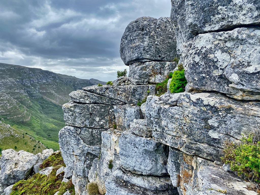
The initial phase of the hike is an invigorating ascent up rocky steps, offering a heart-pumping start. This section is notably steep, and the entire trail provides minimal shade with limited access to water. Approximately 30 minutes into the hike, as you ascend further, the path curves to the right, treating you to breathtaking panoramic views of Hout Bay. The incline becomes less steep at this point, offering a bit of relief.
At the hike’s only junction, choose the right turn to continue your journey around the lower peak towards Chapman’s Peak. Heading straight will lead you to Noordhoek, while a left turn takes you to Blackburn Ravine. This segment features a few steeper sections and rocky steps, so take breaks to soak in the awe-inspiring views along the trail.
Approaching the summit, you’ll start catching glimpses of Noordhoek and the Fish Hoek valley below. Keep pushing forward until you reach the actual summit, not to be confused with lower Chapman’s Peak encountered earlier. Along the way, you’ll encounter abundant fynbos, spot lizards on the rocks, and if you’re fortunate, you might even witness black eagles soaring in the air currents.
The final stretch of the climb involves some scrambling to reach the beacon atop Chapman’s Peak. Standing at 593 meters above sea level, the summit provides an incredible vantage point. From here, you can marvel at Chapman’s Peak Drive below, admire the brilliant white sands of Noordhoek beach, and spot the distant Slangkop lighthouse towards Cape Point. Gazing north, Hout Bay unfolds in all its glory, with superb views of Sentinel Mountain guarding the bay.
In my opinion, this hike offers some of the most spectacular views on the peninsula. Upon reaching the summit, take a moment to relax, savor your drinks and snacks, and soak in the panoramic views. The summit can be windy, so it’s advisable to have a jacket handy. After immersing yourself in the sights, retrace your steps back to the car park. Depending on your fitness levels, the hike typically takes around 3 hours, covering a distance of approximately 5 kilometers round trip.
If you’ve relished this hike, I recommend exploring the old Manganese mine above Hout Bay for another rewarding adventure.
To learn more about this hike please click HERE to visit the old manganese mine above Hout Bay.
Mountain Safety
- Don’t hike alone; four is the ideal number.
- Choose your route carefully and stick to it. Allow yourself enough time – start early. Inform someone of your route and what time you’re expected back.
- Choose a hike leader and walk at the pace of the slowest member.
- If lost – don’t split up. Rather try to retrace your steps. Remember that climbing down is more difficult than climbing up.
- Always take waterproof clothing, even in mid-summer, and wear walking shoes or hiking boots. Wear a hat or cap and sun block in summer. Weather changes rapidly.
- If lost or forced to stop because of bad weather, stay together and remain in one place. Find the closest shelter from wind and rain.
- In case of injury, take time to assess the situation. Then send two people for help and let the third remain with the injured person. If possible, mark the position on a map and send it with those going for help.
- Stick to well-used paths, which will be indicated on the Park’s hiking map and read the warnings on this map. Don’t take shortcuts and especially don’t wander into ravines.
- Always take enough water, especially in summer, and food in case of a delay. Watch the weather and time, and turn back before you start running late or if bad weather threatens.
- Take a fully-charged cellphone. Some parts of the Park do not have cell phone reception, but you will always be able to reach a place where you can use a cell phone more quickly than you’ll get to a landline.
- As Table Mountain is an urban park, please exercise the same common sense and security precautions that you would anywhere else in the world.
- Do not attract unwanted attention by openly displaying cash, cameras or other valuables.
- If you are confronted by a criminal, don’t resist. Handover your goods as resistance might incite a mugger to violence.
- Program emergency numbers in your cellphone before your hike.
These mountain safety tips are provided courtesy of SAN Parks. The numbers below are important and can be used to report suspicious behaviour or any incidents occurring on the mountain during your hike. Program them into your mobile phone before departing on any of your hikes on the Cape Peninsula.
- Main emergency number: 086 110 6417
- Emergency Services: (021) 480 7700
- Central OPS Centre: (021) 467 8002


